Narrow Results By
Fonds
- 1996 Alberta Winter Games Society fonds 1
- Alberta Home Economics Association, Lethbridge Branch fonds 1
- City of Lethbridge Archives Alberta Mines Branch collection 1
- Dr. Hugh Arnold fonds 1
- Oldman River Regional Planning Commission fonds 70
- Phi Delta Kappa, Southern Alberta Chapter fonds 1
- Pioneer Researchers Association Oral History Project 3
- Southwest Alberta Health Services Planning Network fonds 1
- Stafford Family fonds 2
Subject
- Aberhart, William, 1878-1943 1
- Aeronautics - Alberta - History 1
- Aetna (Alta.) -- History. 1
- Agricultural machinery industry - Alberta - History 1
- Agricultural pests - Control - Alberta 1
- Agricultural research - Canada 1
- Agriculture - Alberta 1
- Agriculture - Alberta - Handbooks, manuals, etc. 1
- Agriculture - Alberta - History 2
- Agriculture - Study and teaching 1
- Alberta 2
- Alberta. 1
Name
- 2 & 7 Lethbridge Television 7
- 2&7 Lethbridge Television 4
- 2 & 7 Lethbridge Television Travel Alberta 3
- 1996 Alberta Winter Games Society 1
- Adam, G. Mercer (Graeme Mercer), 1839-1912 1
- Adams, Gary 1
- A. E. Cross 1
- A.E. Cross 1
- A.E.Cross photograph 2
- A.E. Cross Studio 160
- Aerial Survey Section - Department of Lands and Forests - Province of Alberta 253
- Agriculture and Agri-Food Canada 2
Place
- 1 copy in Box 1; 1 copy in Box 21; 1 copy in Box 40: Library Duplicate Titles. 1
- 1 copy in Box 3; 1 copy in Box 20; 1 copy in Box 21; 1 copy in Box 40: Library Duplicate Titles 1
- 1 copy in Box 47: Library Duplicate Titles 1
- 1 copy in Reference Library; 1 copy to NS in Box 47: Library Duplicate Titles. 1
- 1 copy in Reference Pamphlets; 1 copy moved to NS in Box 38: Library Duplicate Titles. 1
- 1 copy moved to NS in Box 20; 1 copy in Box 29; 1 copy in Box 40: Library Duplicate Titles 1
- 1 copy moved to NS in Box 20; 1 copy in Box 40: Library Duplicate Titles 2
- 1 copy moved to NS in Box 20; 1 copy moved to NS in Box 21: Library Duplicate Titles 1
- 1 copy moved to NS in Box 20: Library Duplicate Titles 1
- 1 copy moved to NS in Box 21; 1 copy in Box 27:Library Duplicate Titles 1
- 1 copy moved to NS in Box 21; 1 copy in Box 28; 1 copy in Box 38: Library Duplicate Titles 1
- 1 copy moved to NS in Box 21: Library Duplicate Titles 2

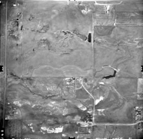
Aerial Survey Photograph of Southern Alberta - Cardston - Township 3 Ranges 25 - 26 West of the 4th Meridian
https://collections.galtmuseum.com/link/descriptions56058
- Material Type
- Photograph
- Date Range
- 29 April 1971
- Description Level
- Item
- Accession No.
- 199910802439
- Physical Description
- 25 cm x 25.5 cm black and white photograph
- Scope and Content
- Aerial survey photograph of southern Alberta - Cardston - Township 3 Ranges 25 - 26 West of the 4th Meridian. The flight index information is "Cardston 82 - H3 49° - 11' - 30" 1:6000 71 - 132 PAN AS 1132 Line 5 77".
- Material Type
- Photograph
- Date Range
- 29 April 1971
- Description Level
- Item
- Physical Description
- 25 cm x 25.5 cm black and white photograph
- Physical Condition
- Excellent
- Scope and Content
- Aerial survey photograph of southern Alberta - Cardston - Township 3 Ranges 25 - 26 West of the 4th Meridian. The flight index information is "Cardston 82 - H3 49° - 11' - 30" 1:6000 71 - 132 PAN AS 1132 Line 5 77".
- Notes
- The flight index map for this photograph is 199910804076 [oversize flat storage].
- Access Restrictions
- Public Access
- Accession No.
- 199910802439
- Collection
- Archive
Images


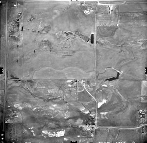
Aerial Survey Photograph of Southern Alberta - Cardston - Township 3 Ranges 25 - 26 West of the 4th Meridian
https://collections.galtmuseum.com/link/descriptions56061
- Material Type
- Photograph
- Date Range
- 29 April 1971
- Description Level
- Item
- Accession No.
- 199910802440
- Physical Description
- 25 cm x 25.5 cm black and white photograph
- Scope and Content
- Aerial survey photograph of southern Alberta - Cardston - Township 3 Ranges 25 - 26 West of the 4th Meridian. The flight index information is "Cardston 82 - H3 49° - 11' - 30" 1:6000 71 - 132 PAN AS 1132 Line 5 78".
- Material Type
- Photograph
- Date Range
- 29 April 1971
- Description Level
- Item
- Physical Description
- 25 cm x 25.5 cm black and white photograph
- Physical Condition
- Excellent
- Scope and Content
- Aerial survey photograph of southern Alberta - Cardston - Township 3 Ranges 25 - 26 West of the 4th Meridian. The flight index information is "Cardston 82 - H3 49° - 11' - 30" 1:6000 71 - 132 PAN AS 1132 Line 5 78".
- Notes
- The flight index map for this photograph is 199910804076 [oversize flat storage].
- Access Restrictions
- Public Access
- Accession No.
- 199910802440
- Collection
- Archive
Images


Aerial Survey Photograph of Southern Alberta - Cardston - Township 3 Ranges 25 - 26 West of the 4th Meridian
https://collections.galtmuseum.com/link/descriptions56062
- Material Type
- Photograph
- Date Range
- 29 April 1971
- Description Level
- Item
- Accession No.
- 199910802441
- Physical Description
- 25 cm x 25.5 cm black and white photograph
- Scope and Content
- Aerial survey photograph of southern Alberta - Cardston - Township 3 Ranges 25 - 26 West of the 4th Meridian. The flight index information is "Cardston 82 - H3 49° - 11' - 30" 1:6000 71 - 132 PAN AS 1132 Line 5 79".
- Material Type
- Photograph
- Date Range
- 29 April 1971
- Description Level
- Item
- Physical Description
- 25 cm x 25.5 cm black and white photograph
- Physical Condition
- Excellent
- Scope and Content
- Aerial survey photograph of southern Alberta - Cardston - Township 3 Ranges 25 - 26 West of the 4th Meridian. The flight index information is "Cardston 82 - H3 49° - 11' - 30" 1:6000 71 - 132 PAN AS 1132 Line 5 79".
- Notes
- The flight index map for this photograph is 199910804076 [oversize flat storage].
- Access Restrictions
- Public Access
- Accession No.
- 199910802441
- Collection
- Archive
Images


Aerial Survey Photograph of Southern Alberta - Cardston - Township 3 Ranges 25 - 26 West of the 4th Meridian
https://collections.galtmuseum.com/link/descriptions56064
- Material Type
- Photograph
- Date Range
- 29 April 1971
- Description Level
- Item
- Accession No.
- 199910802442
- Physical Description
- 25 cm x 25.5 cm black and white photograph
- Scope and Content
- Aerial survey photograph of southern Alberta - Cardston - Township 3 Ranges 25 - 26 West of the 4th Meridian. The flight index information is "Cardston 82 - H3 49° - 11' - 30" 1:6000 71 - 132 PAN AS 1132 Line 5 80".
- Material Type
- Photograph
- Date Range
- 29 April 1971
- Description Level
- Item
- Physical Description
- 25 cm x 25.5 cm black and white photograph
- Physical Condition
- Excellent
- Scope and Content
- Aerial survey photograph of southern Alberta - Cardston - Township 3 Ranges 25 - 26 West of the 4th Meridian. The flight index information is "Cardston 82 - H3 49° - 11' - 30" 1:6000 71 - 132 PAN AS 1132 Line 5 80".
- Notes
- The flight index map for this photograph is 199910804076 [oversize flat storage].
- Access Restrictions
- Public Access
- Accession No.
- 199910802442
- Collection
- Archive
Images

Aerial Survey Photograph of Southern Alberta - Cardston - Township 3 Ranges 25 - 26 West of the 4th Meridian
https://collections.galtmuseum.com/link/descriptions56065
- Material Type
- Photograph
- Date Range
- 29 April 1971
- Description Level
- Item
- Accession No.
- 199910802443
- Physical Description
- 25 cm x 25.5 cm black and white photograph
- Scope and Content
- Aerial survey photograph of southern Alberta - Cardston - Township 3 Ranges 25 - 26 West of the 4th Meridian. The flight index information is "Cardston 82 - H3 49° - 11' - 30" 1:6000 71 - 132 PAN AS 1132 Line 5 81".
- Material Type
- Photograph
- Date Range
- 29 April 1971
- Description Level
- Item
- Physical Description
- 25 cm x 25.5 cm black and white photograph
- Physical Condition
- Excellent
- Scope and Content
- Aerial survey photograph of southern Alberta - Cardston - Township 3 Ranges 25 - 26 West of the 4th Meridian. The flight index information is "Cardston 82 - H3 49° - 11' - 30" 1:6000 71 - 132 PAN AS 1132 Line 5 81".
- Notes
- The flight index map for this photograph is 199910804076 [oversize flat storage].
- Access Restrictions
- Public Access
- Accession No.
- 199910802443
- Collection
- Archive
Images

Aerial Survey Photograph of Southern Alberta - Cardston - Township 3 Ranges 25 - 26 West of the 4th Meridian
https://collections.galtmuseum.com/link/descriptions56066
- Material Type
- Photograph
- Date Range
- 29 April 1971
- Description Level
- Item
- Accession No.
- 199910802444
- Physical Description
- 25 cm x 25.5 cm black and white photograph
- Scope and Content
- Aerial survey photograph of southern Alberta - Cardston - Township 3 Ranges 25 - 26 West of the 4th Meridian. The flight index information is "Cardston 82 - H3 49° - 11' - 30" 1:6000 71 - 132 PAN AS 1132 Line 5 82".
- Material Type
- Photograph
- Date Range
- 29 April 1971
- Description Level
- Item
- Physical Description
- 25 cm x 25.5 cm black and white photograph
- Physical Condition
- Excellent
- Scope and Content
- Aerial survey photograph of southern Alberta - Cardston - Township 3 Ranges 25 - 26 West of the 4th Meridian. The flight index information is "Cardston 82 - H3 49° - 11' - 30" 1:6000 71 - 132 PAN AS 1132 Line 5 82".
- Notes
- The flight index map for this photograph is 199910804076 [oversize flat storage].
- Access Restrictions
- Public Access
- Accession No.
- 199910802444
- Collection
- Archive
Images


Aerial Survey Photograph of Southern Alberta - Cardston - Township 3 Ranges 25 - 26 West of the 4th Meridian
https://collections.galtmuseum.com/link/descriptions56067
- Material Type
- Photograph
- Date Range
- 29 April 1971
- Description Level
- Item
- Accession No.
- 199910802445
- Physical Description
- 25 cm x 25.5 cm black and white photograph
- Scope and Content
- Aerial survey photograph of southern Alberta - Cardston - Township 3 Ranges 25 - 26 West of the 4th Meridian. The flight index information is "Cardston 82 - H3 49° - 11' - 30" 1:6000 71 - 132 PAN AS 1132 Line 5 83".
- Material Type
- Photograph
- Date Range
- 29 April 1971
- Description Level
- Item
- Physical Description
- 25 cm x 25.5 cm black and white photograph
- Physical Condition
- Excellent
- Scope and Content
- Aerial survey photograph of southern Alberta - Cardston - Township 3 Ranges 25 - 26 West of the 4th Meridian. The flight index information is "Cardston 82 - H3 49° - 11' - 30" 1:6000 71 - 132 PAN AS 1132 Line 5 83".
- Notes
- The flight index map for this photograph is 199910804076 [oversize flat storage].
- Access Restrictions
- Public Access
- Accession No.
- 199910802445
- Collection
- Archive
Images


Aerial Survey Photograph of Southern Alberta - Cardston - Township 3 Ranges 25 - 26 West of the 4th Meridian
https://collections.galtmuseum.com/link/descriptions56069
- Material Type
- Photograph
- Date Range
- 29 April 1971
- Description Level
- Item
- Accession No.
- 199910802446
- Physical Description
- 25 cm x 25.5 cm black and white photograph
- Scope and Content
- Aerial survey photograph of southern Alberta - Cardston - Township 3 Ranges 25 - 26 West of the 4th Meridian. The flight index information is "Cardston 82 - H3 49° - 11' - 30" 1:6000 71 - 132 PAN AS 1132 Line 5 84".
- Material Type
- Photograph
- Date Range
- 29 April 1971
- Description Level
- Item
- Physical Description
- 25 cm x 25.5 cm black and white photograph
- Physical Condition
- Excellent
- Scope and Content
- Aerial survey photograph of southern Alberta - Cardston - Township 3 Ranges 25 - 26 West of the 4th Meridian. The flight index information is "Cardston 82 - H3 49° - 11' - 30" 1:6000 71 - 132 PAN AS 1132 Line 5 84".
- Notes
- The flight index map for this photograph is 199910804076 [oversize flat storage].
- Access Restrictions
- Public Access
- Accession No.
- 199910802446
- Collection
- Archive
Images


Aerial Survey Photograph of Southern Alberta - Cardston - Township 3 Ranges 25 - 26 West of the 4th Meridian
https://collections.galtmuseum.com/link/descriptions56084
- Material Type
- Photograph
- Date Range
- 29 April 1971
- Description Level
- Item
- Accession No.
- 199910802457
- Physical Description
- 25 cm x 25.5 cm black and white photograph
- Scope and Content
- Aerial survey photograph of southern Alberta - Cardston - Township 3 Ranges 25 - 26 West of the 4th Meridian. The flight index information is "Cardston 82 - H3 49° - 12' 1:6000 71 - 132 PAN AS 1132 Line 6 95".
- Material Type
- Photograph
- Date Range
- 29 April 1971
- Description Level
- Item
- Physical Description
- 25 cm x 25.5 cm black and white photograph
- Physical Condition
- Excellent
- Scope and Content
- Aerial survey photograph of southern Alberta - Cardston - Township 3 Ranges 25 - 26 West of the 4th Meridian. The flight index information is "Cardston 82 - H3 49° - 12' 1:6000 71 - 132 PAN AS 1132 Line 6 95".
- Notes
- The flight index map for this photograph is 199910804076 [oversize flat storage].
- Access Restrictions
- Public Access
- Accession No.
- 199910802457
- Collection
- Archive
Images


Aerial Survey Photograph of Southern Alberta - Cardston - Township 3 Ranges 25 - 26 West of the 4th Meridian
https://collections.galtmuseum.com/link/descriptions56086
- Material Type
- Photograph
- Date Range
- 29 April 1971
- Description Level
- Item
- Accession No.
- 199910802458
- Physical Description
- 25 cm x 25.5 cm black and white photograph
- Scope and Content
- Aerial survey photograph of southern Alberta - Cardston - Township 3 Ranges 25 - 26 West of the 4th Meridian. The flight index information is "Cardston 82 - H3 49° - 12' 1:6000 71 - 132 PAN AS 1132 Line 6 96".
- Material Type
- Photograph
- Date Range
- 29 April 1971
- Description Level
- Item
- Physical Description
- 25 cm x 25.5 cm black and white photograph
- Physical Condition
- Excellent
- Scope and Content
- Aerial survey photograph of southern Alberta - Cardston - Township 3 Ranges 25 - 26 West of the 4th Meridian. The flight index information is "Cardston 82 - H3 49° - 12' 1:6000 71 - 132 PAN AS 1132 Line 6 96".
- Notes
- The flight index map for this photograph is 199910804076 [oversize flat storage].
- Access Restrictions
- Public Access
- Accession No.
- 199910802458
- Collection
- Archive
Images


Aerial Survey Photograph of Southern Alberta - Cardston - Township 3 Ranges 25 - 26 West of the 4th Meridian
https://collections.galtmuseum.com/link/descriptions56087
- Material Type
- Photograph
- Date Range
- 29 April 1971
- Description Level
- Item
- Accession No.
- 199910802459
- Physical Description
- 25 cm x 25.5 cm black and white photograph
- Scope and Content
- Aerial survey photograph of southern Alberta - Cardston - Township 3 Ranges 25 - 26 West of the 4th Meridian. The flight index information is "Cardston 82 - H3 49° - 12' 1:6000 71 - 132 PAN AS 1132 Line 6 97".
- Material Type
- Photograph
- Date Range
- 29 April 1971
- Description Level
- Item
- Physical Description
- 25 cm x 25.5 cm black and white photograph
- Physical Condition
- Excellent
- Scope and Content
- Aerial survey photograph of southern Alberta - Cardston - Township 3 Ranges 25 - 26 West of the 4th Meridian. The flight index information is "Cardston 82 - H3 49° - 12' 1:6000 71 - 132 PAN AS 1132 Line 6 97".
- Notes
- The flight index map for this photograph is 199910804076 [oversize flat storage].
- Access Restrictions
- Public Access
- Accession No.
- 199910802459
- Collection
- Archive
Images


Aerial Survey Photograph of Southern Alberta - Cardston - Township 3 Ranges 25 - 26 West of the 4th Meridian
https://collections.galtmuseum.com/link/descriptions56088
- Material Type
- Photograph
- Date Range
- 29 April 1971
- Description Level
- Item
- Accession No.
- 199910802460
- Physical Description
- 25 cm x 25.5 cm black and white photograph
- Scope and Content
- Aerial survey photograph of southern Alberta - Cardston - Township 3 Ranges 25 - 26 West of the 4th Meridian. The flight index information is "Cardston 82 - H3 49° - 12' 1:6000 71 - 132 PAN AS 1132 Line 6 98".
- Material Type
- Photograph
- Date Range
- 29 April 1971
- Description Level
- Item
- Physical Description
- 25 cm x 25.5 cm black and white photograph
- Physical Condition
- Excellent
- Scope and Content
- Aerial survey photograph of southern Alberta - Cardston - Township 3 Ranges 25 - 26 West of the 4th Meridian. The flight index information is "Cardston 82 - H3 49° - 12' 1:6000 71 - 132 PAN AS 1132 Line 6 98".
- Notes
- The flight index map for this photograph is 199910804076 [oversize flat storage].
- Access Restrictions
- Public Access
- Accession No.
- 199910802460
- Collection
- Archive
Images


Aerial Survey Photograph of Southern Alberta - Cardston - Township 3 Ranges 25 - 26 West of the 4th Meridian
https://collections.galtmuseum.com/link/descriptions56089
- Material Type
- Photograph
- Date Range
- 29 April 1971
- Description Level
- Item
- Accession No.
- 199910802461
- Physical Description
- 25 cm x 25.5 cm black and white photograph
- Scope and Content
- Aerial survey photograph of southern Alberta - Cardston - Township 3 Ranges 25 - 26 West of the 4th Meridian. The flight index information is "Cardston 82 - H3 49° - 12' 1:6000 71 - 132 PAN AS 1132 Line 6 99".
- Material Type
- Photograph
- Date Range
- 29 April 1971
- Description Level
- Item
- Physical Description
- 25 cm x 25.5 cm black and white photograph
- Physical Condition
- Excellent
- Scope and Content
- Aerial survey photograph of southern Alberta - Cardston - Township 3 Ranges 25 - 26 West of the 4th Meridian. The flight index information is "Cardston 82 - H3 49° - 12' 1:6000 71 - 132 PAN AS 1132 Line 6 99".
- Notes
- The flight index map for this photograph is 199910804076 [oversize flat storage].
- Access Restrictions
- Public Access
- Accession No.
- 199910802461
- Collection
- Archive
Images


Aerial Survey Photograph of Southern Alberta - Cardston - Township 3 Ranges 25 - 26 West of the 4th Meridian
https://collections.galtmuseum.com/link/descriptions56090
- Material Type
- Photograph
- Date Range
- 29 April 1971
- Description Level
- Item
- Accession No.
- 199910802462
- Physical Description
- 25 cm x 25.5 cm black and white photograph
- Scope and Content
- Aerial survey photograph of southern Alberta - Cardston - Township 3 Ranges 25 - 26 West of the 4th Meridian. The flight index information is "Cardston 82 - H3 49° - 12' 1:6000 71 - 132 PAN AS 1132 Line 6 100".
- Material Type
- Photograph
- Date Range
- 29 April 1971
- Description Level
- Item
- Physical Description
- 25 cm x 25.5 cm black and white photograph
- Physical Condition
- Excellent
- Scope and Content
- Aerial survey photograph of southern Alberta - Cardston - Township 3 Ranges 25 - 26 West of the 4th Meridian. The flight index information is "Cardston 82 - H3 49° - 12' 1:6000 71 - 132 PAN AS 1132 Line 6 100".
- Notes
- The flight index map for this photograph is 199910804076 [oversize flat storage].
- Access Restrictions
- Public Access
- Accession No.
- 199910802462
- Collection
- Archive
Images


Aerial Survey Photograph of Southern Alberta - Cardston - Township 3 Ranges 25 - 26 West of the 4th Meridian
https://collections.galtmuseum.com/link/descriptions56091
- Material Type
- Photograph
- Date Range
- 29 April 1971
- Description Level
- Item
- Accession No.
- 199910802463
- Physical Description
- 25 cm x 25.5 cm black and white photograph
- Scope and Content
- Aerial survey photograph of southern Alberta - Cardston - Township 3 Ranges 25 - 26 West of the 4th Meridian. The flight index information is "Cardston 82 - H3 49° - 12' 1:6000 71 - 132 PAN AS 1132 Line 6 101".
- Material Type
- Photograph
- Date Range
- 29 April 1971
- Description Level
- Item
- Physical Description
- 25 cm x 25.5 cm black and white photograph
- Physical Condition
- Excellent
- Scope and Content
- Aerial survey photograph of southern Alberta - Cardston - Township 3 Ranges 25 - 26 West of the 4th Meridian. The flight index information is "Cardston 82 - H3 49° - 12' 1:6000 71 - 132 PAN AS 1132 Line 6 101".
- Notes
- The flight index map for this photograph is 199910804076 [oversize flat storage].
- Access Restrictions
- Public Access
- Accession No.
- 199910802463
- Collection
- Archive
Images


Aerial Survey Photograph of Southern Alberta - Cardston - Township 3 Ranges 25 - 26 West of the 4th Meridian
https://collections.galtmuseum.com/link/descriptions56092
- Material Type
- Photograph
- Date Range
- 29 April 1971
- Description Level
- Item
- Accession No.
- 199910802464
- Physical Description
- 25 cm x 25.5 cm black and white photograph
- Scope and Content
- Aerial survey photograph of southern Alberta - Cardston - Township 3 Ranges 25 - 26 West of the 4th Meridian. The flight index information is "Cardston 82 - H3 49° - 12' 1:6000 71 - 132 PAN AS 1132 Line 6 102".
- Material Type
- Photograph
- Date Range
- 29 April 1971
- Description Level
- Item
- Physical Description
- 25 cm x 25.5 cm black and white photograph
- Physical Condition
- Excellent
- Scope and Content
- Aerial survey photograph of southern Alberta - Cardston - Township 3 Ranges 25 - 26 West of the 4th Meridian. The flight index information is "Cardston 82 - H3 49° - 12' 1:6000 71 - 132 PAN AS 1132 Line 6 102".
- Notes
- The flight index map for this photograph is 199910804076 [oversize flat storage].
- Access Restrictions
- Public Access
- Accession No.
- 199910802464
- Collection
- Archive
Images


Aerial Survey Photograph of Southern Alberta - Cardston - Township 3 Ranges 25 - 26 West of the 4th Meridian
https://collections.galtmuseum.com/link/descriptions56137
- Material Type
- Photograph
- Date Range
- 29 April 1971
- Description Level
- Item
- Accession No.
- 199910802479
- Physical Description
- 25 cm x 25.5 cm black and white photograph
- Scope and Content
- Aerial survey photograph of southern Alberta - Cardston - Township 3 Ranges 25 - 26 West of the 4th Meridian. The flight index information is "Cardston 82 - H3 49° - 12' - 30" 1:6000 71 - 132 PAN AS 1132 Line 7 119".
- Material Type
- Photograph
- Date Range
- 29 April 1971
- Description Level
- Item
- Physical Description
- 25 cm x 25.5 cm black and white photograph
- Physical Condition
- Excellent
- Scope and Content
- Aerial survey photograph of southern Alberta - Cardston - Township 3 Ranges 25 - 26 West of the 4th Meridian. The flight index information is "Cardston 82 - H3 49° - 12' - 30" 1:6000 71 - 132 PAN AS 1132 Line 7 119".
- Notes
- The flight index map for this photograph is 199910804076 [oversize flat storage].
- Access Restrictions
- Public Access
- Accession No.
- 199910802479
- Collection
- Archive
Images


Aerial Survey Photograph of Southern Alberta - Cardston - Township 3 Ranges 25 - 26 West of the 4th Meridian
https://collections.galtmuseum.com/link/descriptions56138
- Material Type
- Photograph
- Date Range
- 29 April 1971
- Description Level
- Item
- Accession No.
- 199910802480
- Physical Description
- 25 cm x 25.5 cm black and white photograph
- Scope and Content
- Aerial survey photograph of southern Alberta - Cardston - Township 3 Ranges 25 - 26 West of the 4th Meridian. The flight index information is "Cardston 82 - H3 49° - 12' - 30" 1:6000 71 - 132 PAN AS 1132 Line 7 120".
- Material Type
- Photograph
- Date Range
- 29 April 1971
- Description Level
- Item
- Physical Description
- 25 cm x 25.5 cm black and white photograph
- Physical Condition
- Excellent
- Scope and Content
- Aerial survey photograph of southern Alberta - Cardston - Township 3 Ranges 25 - 26 West of the 4th Meridian. The flight index information is "Cardston 82 - H3 49° - 12' - 30" 1:6000 71 - 132 PAN AS 1132 Line 7 120".
- Notes
- The flight index map for this photograph is 199910804076 [oversize flat storage].
- Access Restrictions
- Public Access
- Accession No.
- 199910802480
- Collection
- Archive
Images


Aerial Survey Photograph of Southern Alberta - Cardston - Township 3 Ranges 25 - 26 West of the 4th Meridian
https://collections.galtmuseum.com/link/descriptions56139
- Material Type
- Photograph
- Date Range
- 29 April 1971
- Description Level
- Item
- Accession No.
- 199910802481
- Physical Description
- 25 cm x 25.5 cm black and white photograph
- Scope and Content
- Aerial survey photograph of southern Alberta - Cardston - Township 3 Ranges 25 - 26 West of the 4th Meridian. The flight index information is "Cardston 82 - H3 49° - 12' - 30" 1:6000 71 - 132 PAN AS 1132 Line 7 121".
- Material Type
- Photograph
- Date Range
- 29 April 1971
- Description Level
- Item
- Physical Description
- 25 cm x 25.5 cm black and white photograph
- Physical Condition
- Excellent
- Scope and Content
- Aerial survey photograph of southern Alberta - Cardston - Township 3 Ranges 25 - 26 West of the 4th Meridian. The flight index information is "Cardston 82 - H3 49° - 12' - 30" 1:6000 71 - 132 PAN AS 1132 Line 7 121".
- Notes
- The flight index map for this photograph is 199910804076 [oversize flat storage].
- Access Restrictions
- Public Access
- Accession No.
- 199910802481
- Collection
- Archive
Images


Aerial Survey Photograph of Southern Alberta - Cardston - Township 2 Ranges 25-26 West of the 4th Meridian
https://collections.galtmuseum.com/link/descriptions56003
- Material Type
- Photograph
- Date Range
- 29 April 1971
- Description Level
- Item
- Accession No.
- 199910802402
- Physical Description
- 25 cm x 25.5 cm black and white photograph
- Scope and Content
- Aerial survey photograph of southern Alberta - Cardston - Township 2 Ranges 25-26 West of the 4th Meridian. The flight index information is "Cardston 82 - H3 49° - 10' - 30" 1:6000 71 - 132 PAN AS 1132 Line 3 40".
- Material Type
- Photograph
- Date Range
- 29 April 1971
- Description Level
- Item
- Physical Description
- 25 cm x 25.5 cm black and white photograph
- Physical Condition
- Excellent
- Scope and Content
- Aerial survey photograph of southern Alberta - Cardston - Township 2 Ranges 25-26 West of the 4th Meridian. The flight index information is "Cardston 82 - H3 49° - 10' - 30" 1:6000 71 - 132 PAN AS 1132 Line 3 40".
- Notes
- The flight index map for this photograph is 199910804076 [oversize flat storage].
- Access Restrictions
- Public Access
- Accession No.
- 199910802402
- Collection
- Archive
Images

{{ server.message }}